
HARVEY, YORK Co, NB – TheNewswire – June 8, 2021 – Edge Exploration Inc. (“EDGE”) is delighted to announce that it has been awarded $25,000 under the New Brunswick Junior Mining Assistance Program (NBJMAP). EDGE is a mineral exploration project conception and implementation company that applies leading-edge technology. NBJMAP grants provide 50% of eligible costs, with the recipient responsible for the other 50%. Any unmatched amount must be returned to the government. Last year, a grant of $15,000 to EDGE triggered a total expenditure of $81,600, not including HST, for drilling, sample analysis, transportation and contracted geological services.
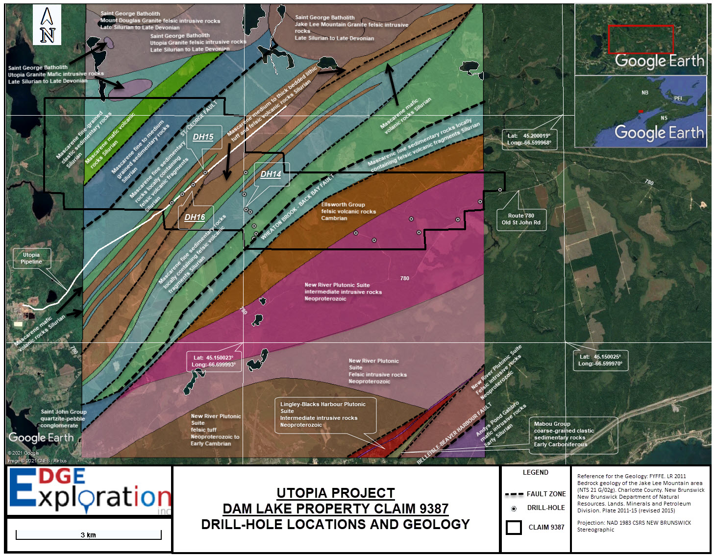
The December 2020-February 2021 drilling program expenditure was for 17 cored holes to test for gold and other metals in an area east of Lake Utopia where thick overburden and scarce bedrock outcrops had deterred prospecting and exploration. Three of the holes close to each other discovered gold, silver and tungsten in the overburden and in sufficient amounts to signal a nearby bedrock source or sources.
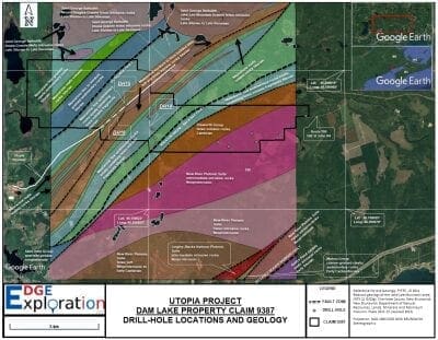
Two of these uncommonly anomalous sites are 420 m apart along a natural gas pipeline right of way to the Utopia Paper Mill (DHs 15 & 16), and the third (DH 14) is 1.2 km southeast of DH 15. High priority targets for gold and multi-metals were identified in the immediate area by an Aster Funds Ltd.(“Aster”) Long Wave Infrared (LWIR) satellite imagery interpretation done in preparation for the drilling program. The imagery shows a concentration of pyrite, arsenopyrite and cordierite enveloping the priority targets.
The table below provides analytical results by Actlabs for the elements of economic interest in the very fine sand, silt and clay portion (< 0.177mm) separated by lab-sieving the drill samples. Each sampled interval from these holes was 5 to 6 cm in diameter.
|
Notes: 1) “INAA” stands for Instrumental Neutron Activation Analysis (Actlabs code “1D Enhanced”), on DH 14, 15 & 16 samples; and “FAAA” for Fire Assay and Atomic Absorption (Actlabs code “FA-AA”) on all till/overburden samples from the 17-hole drill program. Samples from DH 15 through 18 were analyzed by Actlabs code “Ultratrace 3” for gold (in addition to FA-AA) and other elements. Descriptions of these methods are on the Actlabs website https://actlabs.com/geochemistry/explorationgeochemistry
2) DH 14 entered banded argillite or volcanic tuff bedrock at 9m, continuing to the end of the hole at 11m. DH15 entered similar bedrock at 1.85m which continued to the end of the hole at 4m. DH 16 was drilled to 13m without encountering bedrock, but angular argillite or tuff fragments dominated pebbles and cobbles above the 12.2 to 13m sample.
In May 2019, EDGE and Fancamp Exploration Ltd. (“Fancamp”) commenced a mutual benefits cooperation relationship following a meeting by EDGE’s management with Dr. Peter H. Smith while attending the annual conference of the Canadian Institute of Mining, Metallurgy and Petroleum (“CIM”) in Montreal. The meeting was suggested by Mac Watson, who the EDGE president happened to meet on the floor of the conference and who was aware that EDGE had just been incorporated. Its principals had been shopping a property for some time with little success in the then bear market for grassroots project funding. EDGE’s only property at the time was the Mactaquac alluvial gold discovery, where the bedrock intrusion-related attributes are similar to those of the Clarence Stream gold discovery, which Freewest, when shepherded by Mac, had introduced to the exploration world and had outlined the first resource.
Most importantly for exploration success, Fancamp’s Dr. Smith not only agreed to option the Mactaquac property but also suggested that we begin a collegial project conception relationship to jointly identify overlooked or insufficiently tested opportunities of technical merit in New Brunswick. The working relationship on the Mactaquac claim and project conception has proven to be collegial and productive.
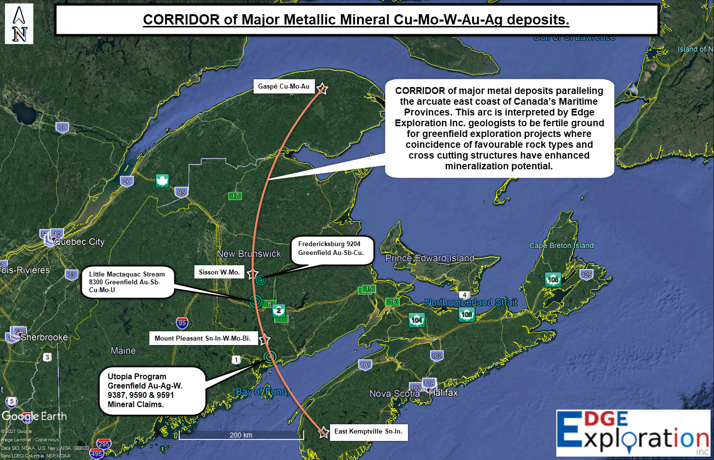
The Fredericksburg claim 9204, about 30 km north of Mactaquac, encompasses the first area identified as having acceptable gold, antimony and copper potential. Government geochemical surveys in the early 2000s had detected very anomalous gold, antimony and copper in soils. Subsequently, only confirmatory geochemical surveying, including overburden drill sampling, had been conducted by industry. When discussing our focus for selecting properties of merit, it was observed that Mactaquac and Fredericksburg are both on or near a north-south band of mineral occurrences and physical features. Dr. Smith suggested that we focus property selection along this band and refer to all such properties acquired as part of our “Corridor 50-50 cost and benefit shared program” (see accompanying map).
The second identified area that met our agreed criteria for qualifying as a Corridor property to be jointly registered was east of Lake Utopia. Dr. Smith advocated referring to claims in the immediate area as part of “The Utopia Project.” The Dam Lake Claim 9387 (2,480 ha), registered initially as three separate claims in January 2020, was the first property to be acquired under this project. An additional two claims subsequently have been added, bringing total Utopia Project hectares to 4,707.
Before the rush that saw the area from the border with Maine to the city of Saint John being fully blanketed by claims, the EDGE-Fancamp team, fortunately, had selected the claim 9387 area as a valid exploration target because of:
-
– early Silurian Mascarene sediments and volcanics similar to those hosting Clarence Stream gold deposit zones currently being drilled by Galway Metals Inc.
– major NE-trending faults of which several are close to gold and other metal occurrences along strike
– fault splays that trend as at Clarence Stream from the major NE-trending faults toward the St. George Batholith as interpreted from a 1989 magnetic survey for Noranda
– being on the arcuate corridor connecting four significant multi-metal deposits
– well located near the coast, a workforce, roads, natural gas pipeline and acceptance of Utopia Paper Mill.
As mentioned above, in preparation for the overburden drilling program, a study of SW New Brunswick satellite imagery was contracted to Aster (https://www.asterfunds.com/) by EDGE and Fancamp to map and identify from the 16 minerals outlined by a LWIR satellite survey those minerals most commonly associated with gold and other metallic mineral deposits. Aster’s John Ryder describes the company as providing:
A low-cost mineral exploration technology that enables early-stage exploration via high-quality satellite imagery analysis (LWIR, SWIR, SAR, LDFC/QDFC Predictive Mapping). Detailed images outline 16 Long Wave InfraRed (LWIR) and Short-Wave Infrared (SWIR) end members. Each mineral on the images gets correlated/cataloged into a group with exploration relevance to precious metals deposits, base metals deposits, and industrial minerals deposits. Target Vector Minerals (TVM’s) have identified spatial association with known mineralization in the survey area, and TVM overlaps mapping has assisted in outlining exploration targets.
An LWIR survey and TVM mapping over the Utopia claim outlined gold, copper and metallic TVM target areas close to overburden drill holes DH14, DH15 and DH16.
Qualified Person
Dallas Davis, P.Eng., FEC, Director and President of EDGE, is a Qualified Person, as is Adrian Davis, P. Geo.. Both were responsible for preparing scientific and technical disclosure on behalf of EDGE for this news release.
Sample integrity and analysis
Drill supervision, core box transportation, sampling, logging and storage have been undertaken personally by Adrian Davis, P. Geo., of XplorEv Geological Services. Sampling was done jointly with Dallas Davis. Samples were delivered personally by Dallas Davis to the Actlabs sample preparation facility in Fredericton, New Brunswick. Blanks and certified standards were inserted and analyzed according to the protocol of Actlabs, a company with ISO/IEC 17025 accreditation. EDGE will insert blanks and standards once the nature of bedrock mineralization is known and the most appropriate standard obtained based on this knowledge.
“Actlabs” in this news release refers to Activation Laboratories Ltd., 41 Bittern St., Ancaster, ON L9G 4V5. Analytical methods used on till samples from the Utopia Project are under “Notes” at the base of the above analytical results table.
About the Company
Edge Exploration Inc. is a private unlisted company specializing in identifying priority targets for mineral deposit discovery or evaluation, either on its own initiative or on behalf of clients. In addition, it seeks to option property interests to more senior parties or otherwise procure funding and manage the work necessary to prove or disprove commercial potential. EDGE works closely with and draws upon the expertise of Dalmin Corporation, XplorEv Geological Services and Kramers Drone Services.
Edge Exploration Inc.
Dallas Davis, P. Eng., FEC
President
1-506-449-2665
Office address:
Upper Village Mall, Unit 4, 2306 Route 3, Harvey, NB E6K 1P2
NOTE: Images below are in jpg format and will be on the EDGE website.
Click Image To View Full Size
Click Image To View Full Size
Click Image To View Full Size
Copyright (c) 2021 TheNewswire – All rights reserved.